Ricarica risultati ...

Suggerimenti per Sentiero per escursioni vicino a Hong Kong

Filtri:
    • 9.5
      (山頂晨運徑)
      Sentiero
      Harlech Rd and Lugard Rd, 山顶
      Salva
      • Matt T.

        Matt T. • Gennaio 2, 2016Easy trail walk around the peak. Really gentle with very little up and down. Amazing views out over HK and Victoria harbour. Definitely worth doing, takes about 1 - 1.5hrs to complete.

    • 9.3
      (龍脊)
      Sentiero
      Shek O Country Park, Dragon's Back
      Salva
      • Jun W.

        Jun W. • Ottobre 26, 2015Beautiful views, just need around 2 & 45 mins, very worth to take the times to walk this amazing trail. Easy to walk too, many signs to guide thru the trail, especially wf hk gov's apps 'enjoy hiking'

    • 8.5
      (港島徑(第一段))
      Sentiero
      山顶
      Salva
      • ALF

        ALF • Novembre 5, 2015Starts near the peak and is rather easy if you start there. Maximum two hours until section 2 - or the bus stop near the reservoir. Great views towards all directions.

    • 8.4
      Sentiero
      Shek O Country Park, 石澳
      Salva
      • Gregory K.

        Gregory K. • Dicembre 6, 2015Some good trails. Not too difficult. Easy for all ages

    • 8.9
      (寶雲道健身徑)
      Sentiero
      Bowen Rd, 灣仔
      Salva
      • Matt T.

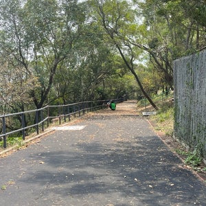
        Matt T. • Febbraio 25, 2017Flat, tarmacced trail that is about 4.1km long. Lots of joggers use this route and you get some truly exceptional views out over HK island. This is my favourite easy walk in HK.
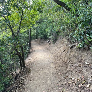
    • 8.1
      (衛奕信徑(第一段))
      Sentiero
      Tai Tam Country Park (Stanley Gap Road), Tai Tam
      Salva
      • Julien

        Julien • Aprile 2, 2018Challenging hike! A must-do in Hong Kong, and to do again and again (if you are not afraid of stairs of course) :-)

    • 8.6
      Sentiero
      Lantau Island
      Salva
      • Nurlan N.

        Nurlan N. • Ottobre 29, 2014Wonderful views. Really worth going there.

    • 8.4
      (心經簡林)
      Sentiero
      Lantau Trail, Ngong Ping
      Salva
      • Aini M.

        Aini M. • Luglio 6, 2015Utk menuju ke tempat ini, harus melewati hutan dan menanjak bukit.. Tp begitu sampai tempatnya, kita akan bs ngeliat gunung besar yang sangat bagus dan jalanan setapak dengan wisdom word disekitarnya.

    • 8.4
      Sentiero
      Tai Tam
      Salva
      • Rohit

        Rohit • Giugno 1, 2014Do it as early in the morning as you can and carry water! It is a hard hike! But the views - oh my god!!

    • Salva
      • Ivan N.

        Ivan N. • Aprile 6, 2015Enjoy the green view and spot the heritage stone dam

    • 7.9
      (港島徑(第三段))
      Sentiero
      Aberdeen Country Park, Aberdeen
      Salva
      • Ivan N.

        Ivan N. • Giugno 7, 2015That is the junction between section 2 and 3, don't miss it!

    • 8.2
      (大風坳)
      Sentiero
      Tai Tam
      Salva
      • Ivan N.

        Ivan N. • Maggio 31, 2015Only 300m high and connecting to most hiking trails on the island east.

    • 8.0
      (香港仔郊野公園)
      Sentiero
      Aberdeen
      Salva
      • Ivan N.

        Ivan N. • Giugno 7, 2015It start from here !!

    • 8.0
      (浪茄)
      Sentiero
      Long Ke Wan, 西貢
      Salva
      • Fred S.

        Fred S. • Agosto 28, 2013Beautiful beach. There is a toilet and seasonal fresh water supply (non drinkable). Water is not as clean as the Tai long beaches (Sai wan, Ham tin wan)

    • 7.9
      (龍虎山郊野公園)
      Sentiero
      Hatton Rd, 薄扶林
      Salva
      • Ivan N.

        Ivan N. • Aprile 12, 2015Find this 100 years plus corner stone - was used to define the boundary of Victoria City ( now upper central to wan chai )

    • 7.5
      (麥理浩徑(第十段))
      Sentiero
      Tai Lam Country Park, New Territories
      Salva
      • Ivan N.

        Ivan N. • Dicembre 13, 2015Great view of Red leaves in Winter time near Tai Tong !

    • 7.5
      Sentiero
      Pak Mong to Mui Wo
      Salva
      • pin l.

        pin l. • Aprile 23, 2023Totally enjoyed walking thro d village to reach start of trail. Only managed to hike for 2 km - many steps uphill all d way w great views. Stop at waterfall n cave (pavilion to rest n some stray dogs.

    • 7.7
      Sentiero
      西貢
      Salva
      • jenny t.

        jenny t. • Agosto 25, 2015crisp clear waters all year round.

    • 7.6
      Sentiero
      Lugard Rd, 山顶
      Salva
      • Jörg W.

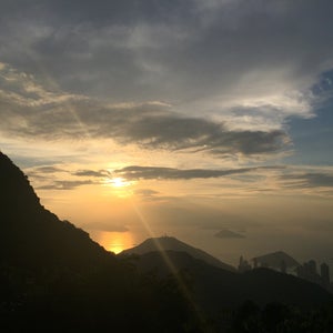
        Jörg W. • Dicembre 4, 2010Go here in the evening, avoid the crowded Peak Tower and enjoy the mindblowing view over HK from a calm and relaxed viewpoint in the middle of Mother Nature. It's just one of a kind.

    • 7.4
      (大埔滘自然教育徑)
      Sentiero
      Tai Po Kau
      Salva
      • Douglas C.

        Douglas C. • Marzo 4, 2020One of my favorite place for hiking, normally four routes to choose.

    • 7.6
      (石澳郊野公園)
      Parco Nazionale
      石澳
      Salva
      • Robert T.

        Robert T. • Gennaio 18, 2015The terrain is a little rough but it is a great hike with stunning views of the ocean.

    • 7.6
      Sentiero
      Plover Cove Country Park, Shuen Wan
      Salva
      • Ivan N.

        Ivan N. • Novembre 8, 2015This is the start point of Plover cove reservoir country trail !

    • 7.3
      Sentiero
      Black's Link, Hong Kong
      Salva
      • Ivan N.

        Ivan N. • Marzo 5, 2017Don't miss the St. John war memorial near the interchange.

    • 7.2
      (金督馳馬徑)
      Sentiero
      Sir Cecil's Ride, Tai Tam
      Salva
      • Ivan N.

        Ivan N. • Aprile 24, 2016One of the best location to shot the HK island and Kowloon side together.

    • 7.0
      (鰂魚涌樹木研習徑)
      Sentiero
      Mt Parker Road
      Salva
      • Ivan N.

        Ivan N. • Settembre 27, 2015The stoves for war-time have been transformed into gardening pots - well thought !

    • 7.0
      Sentiero
      Sai Kung, 西貢
      Salva
      • Wong K.

        Wong K. • Ottobre 14, 2013Including section 2, these two bits are the best of MacLehose trail for enjoying the real magic of HK's beautiful countryside.

    • 6.7
      (麥理浩徑(第五段))
      Sentiero
      Lion Rock Country Park, Lion Rock
      Salva
      • Ivan N.

        Ivan N. • Marzo 22, 2015Find the '100' trail plate means you are in the mid point of MacLehose trail

    • 6.6
      (手指山)
      Sentiero
      Peng Chau
      Salva
      • John B.

        John B. • Febbraio 15, 2015Be prepared for lots of steps but worth it for the views

    • 6.4
      (Central Green Trail 中區自然徑)
      Sentiero
      Mid-levels
      Salva
      • Sabrina M.

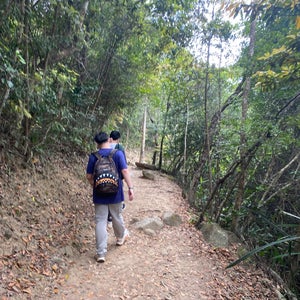
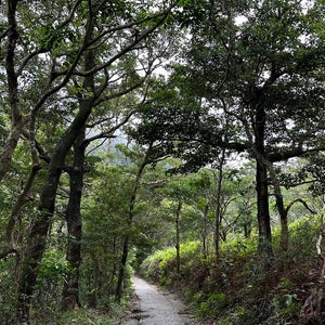
        Sabrina M. • Aprile 3, 2016Nice trail with a mix of urban/city surroundings and nature and not at all crowded. Easy to follow silver signs. A lot of it is quite steep though.

    • ?
      Sentiero
      鳳凰徑, 大嶼山
      Salva
    • Non trovi il posto che stai cercando? Aggiungi un nuovo posto a foursquare .